Menu

Fishermans Bend Urban Design Strategy


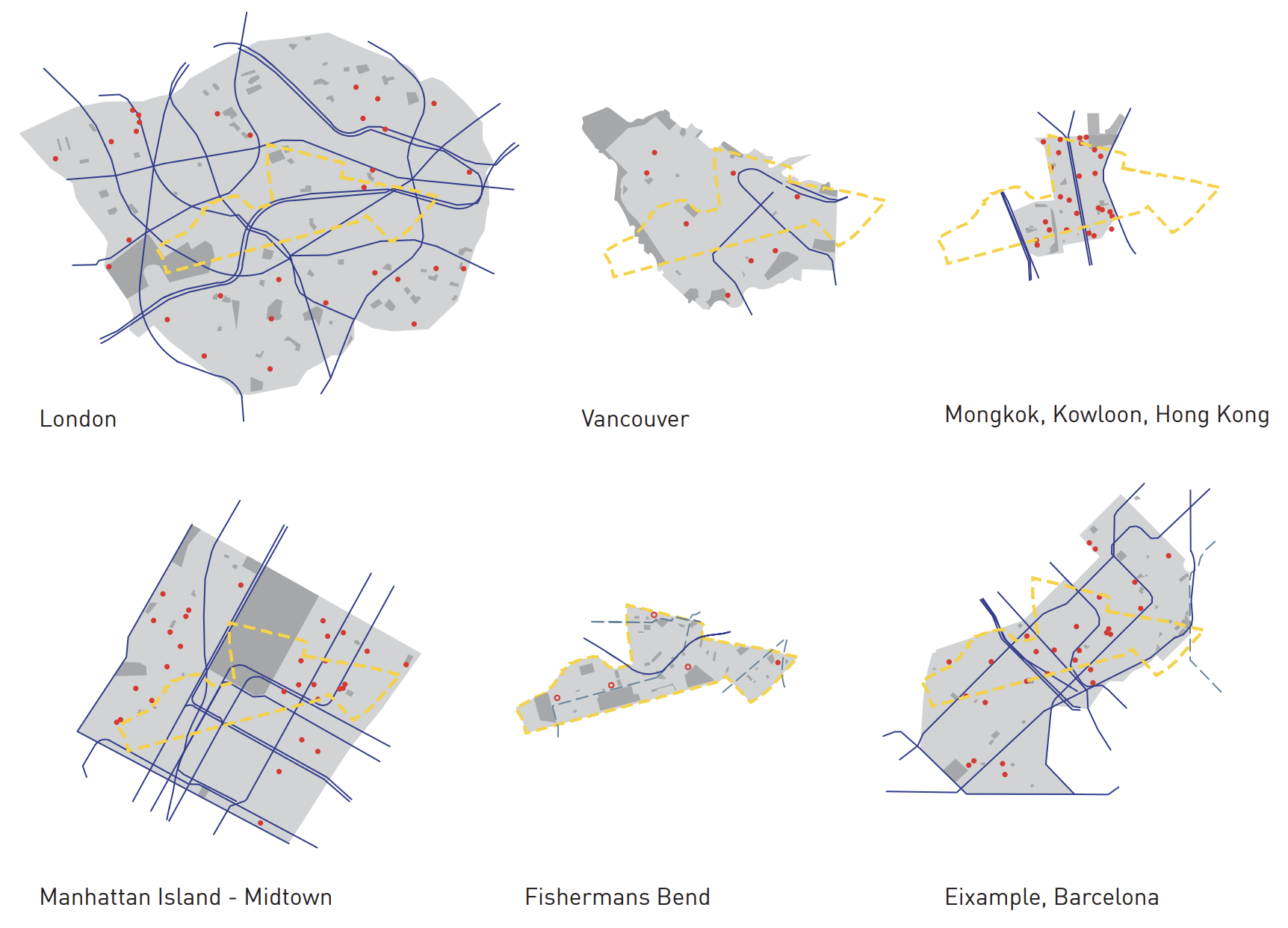
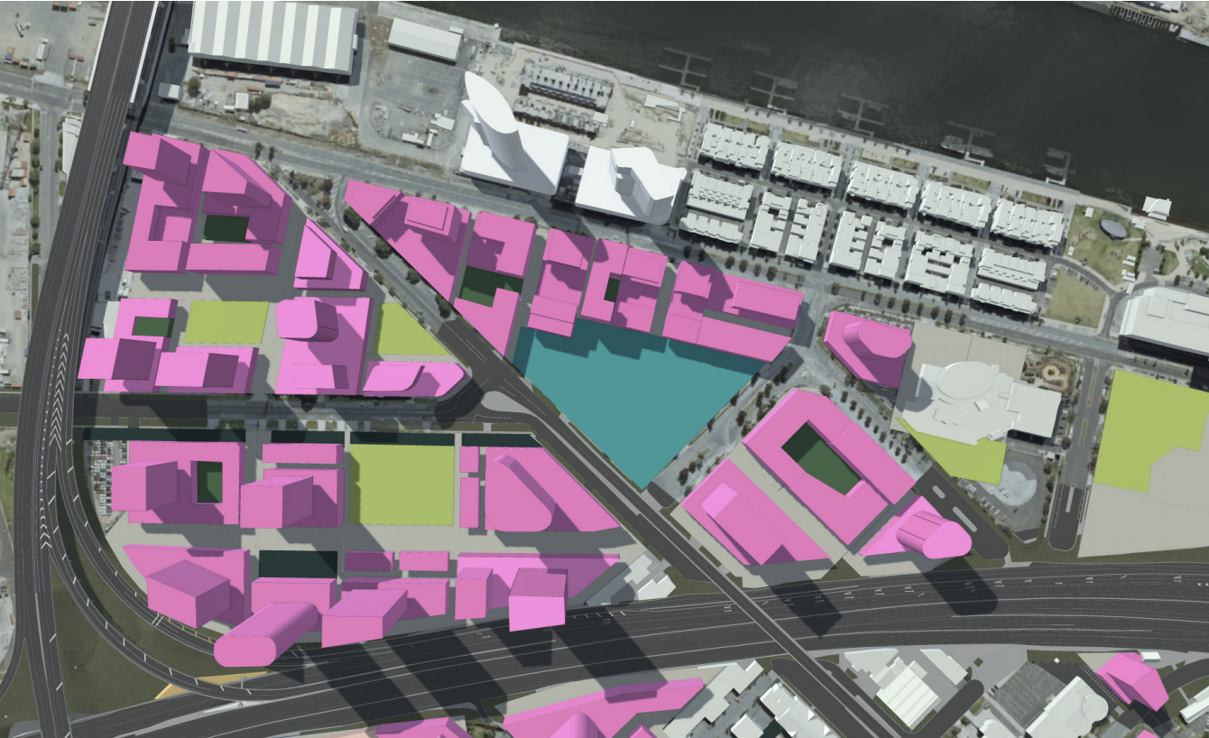
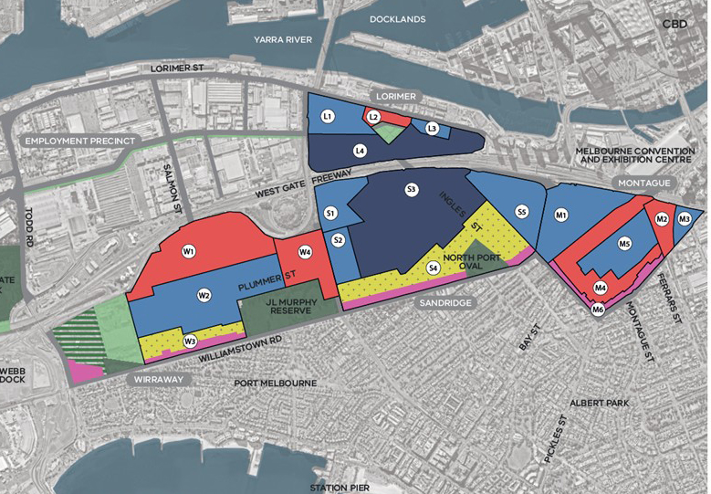
Fishermans Bend is Australia’s largest urban renewal project. In 2012, 250 hectares of land on the edge of Melbourne’s CBD was rezoned to deliver an ambitious transformation of an existing industrial area into four new mixed-use neighbourhoods housing 80,000 people and 40,000 employees. The rezoning preceded any planning work creating significant challenges in delivering on the vision. The urban renewal project has a 35 year timeline and as such, considered approaches to land use, density and the built form will be imperative to the precinct’s success.

The Fishermans Bend Urban Renewal Precinct will have four new mixed use neighbourhoods and an employment precinct.

Between 2012 and 2015, the project was subject to a series of planning interventions that accumulated in a confused and highly contested planning context and low community confidence in the future of the area. In 2016, the planning for Fishermans Bend was recast and significant work was initiated for new transport, open space and infrastructure planning as well as the preparation of an urban design strategy to guide the overall character of each neighbourhood, including densities and land use mix.

A key challenge in the development of an urban design strategy was arresting poor development trends that were emerging in development permit approvals. This included very high residential densities, inadequate building separation and a lack of housing diversity.

Residential densities in comparable inner city precincts and development trends in Fishermans Bend in 2015 prior to new planning controls.

Our work aligned the identified strategic objectives for Fishermans Bend, including the enhancement of employment opportunities, creation of new open public space and streets and the delivery affordable housing, with the design objectives, including the creation of walkable, healthy and characterful neighbourhoods.

The urban design strategy introduced sophisticated built form controls that support flexible design outcomes and design excellence. This included support for hybrid developments that incorporate a range of housing typologies, the introduction of density controls to manage overall growth and tailored built form controls to support the realisation of the preferred neighbourhood character in each precinct.

Our work was informed by comprehensive 3d built form testing to enable the development of tailored controls that responded to site conditions within each precinct.

Leanne Hodyl was the key urban design expert witness for the state government and successfully argued for the introduction of a new design approach.

Existing character in Montague precinct: Industrial warehouses along Tate Street in Fishermans Bend.
Model illustrating how Montague might look by 2050. The red buildings indicate poor development trends in approved permits prior to 2015. The remaining sites illustrate a more reasonable scale of densities, a diversity of housing typologies and new development that is aligned with the preferred character for the area.

The planning for Fishermans Bend has been highly controversial, with diverse stakeholders challenging the proposed development outcomes for the area over the past 6 years. The Urban Design Strategy was finalised in 2017 and provided the strategic justification to support significant revisions to the existing planning controls. The revised planning controls will now guide the transformation of each precinct into well-designed, characterful and diverse mixed-use precincts. These were supported in a review by an independent panel and now apply to all new development.

Media

New tram over Yarra, train line and tower heights put into Fishermans Bend plan

Fishermans Bend's Urban Design Strategy Visuals

New vision for Fishermans Bend: Towers cut down to size, car parks limited

Finalisation of Fishermans Bend Framework

Fishermans Bend developers face height restrictions under new planning rules

Related Projects

Central Melbourne Built Form Review

Moonee Ponds Built Form Framework

Fishermans Bend Employment Precinct Plan

Fitzroy Precinct Development Plan and Housing Feasibility


Hodyl & Co worked collaboratively with Fender Katsalidis Architects to provide built form and urban design rationale to inform the preparation of a Development Plan Overlay for the Brotherhood of St Laurence’s Fitzroy Precinct that would be responsive to the unique neighbourhood character and support the aspirations of the Brotherhood to create an inclusive and vibrant community hub.

A range of scenarios were considered to determine the most appropriate built form outcomes that would ensure a respectful response to the existing heritage quality, and balance the development potential with visual amenity implications. The recommendation included the pairing of a mandatory FAR requirement alongside a discretionary height limit to deliver an intensity of development that was appropriate for the site while achieving positive amenity and urban design outcomes.

Built form testing

As part of this project, Hodyl & Co worked collaboratively with Savills to develop a Housing Feasibility Report for Fitzroy Precinct to investigate the viability and types of social and affordable housing suited to the Fitzroy Precinct project. This analysis identified opportunities to deliver social and affordable housing aligned with local need and the Brotherhood of St Laurence’s strategic priorities for the site. A range of development feasibility scenarios were tested informed by a clear understanding of the social and affordable housing policy context and innovative funding, delivery and operational models available to support such development.

Housing continuum diagram
Context map